

Soldiers
have been working in Staines putting up a dam in a field to redirect
water away from housing into fields. The soldiers are from C company
Royal Ghurka Rifles. Photo: Crown Copyright
The
deployment of the Tornado GR4 from RAF Marham in Norfolk has produced
detailed imagery that will aid the planning and co-ordination of
multi-agency efforts to provide relief to local residents and
communities. Photo: Crown Copyright
While soldiers creating sandbag walls and flood defense are a regular view in the flood stricken areas, the RAF has provided additional support from above, committing surveillance aircraft to provide authorities a unique picture of the situation on the ground.
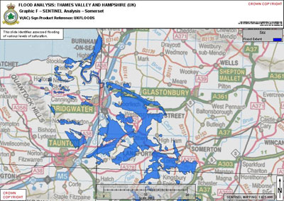
Flooded
area analysis of the Thames Valley and Hampshire, UK generated by SAR
imaging provided by Sentinel R1 sortie over Somerset. The Sentinel was
operated by the RAF’s 5 (Army Cooperation) Squadron from RAF Waddington
in Lincolnshire. Photo: Crown Copyright
By using the imagery gathered by both systems, civilian authorities will be able to compare the current flooding in the Thames Valley to how the same area was affected during a similar devastating period of flooding in 1947 which was caused by melting snow and extended periods of heavy rain. Being able to draw comparisons may help to indicate what areas are most likely to be affected next and help the civilian authorities to make informed decisions about where best to target their efforts.
“The Sentinel has long-range capabilities which enable highly trained Airborne Image Analysts onboard to capture imagery of large parts of the flooded areas.” Squadron Leader Victoria Fulton, Chief of Staff 5 (Army Co-operation) Squadron saID, “It is hoped that this key information will greatly assist the civilian authorities when determining where best to focus their efforts.”
The Tornado aircraft and RAPTOR has been used in many military operations and is currently in use over Afghanistan. It was selected for this task as it can rapidly scan and capture a huge area of interest in just one sortie – in this case areas in need of flood relief work.
“The sortie launched today demonstrates the versatility of both the [Tornado] aircraft and its reconnaissance systems and of the men and women who support those operations.” Wing Commander Neil Tomlin, Acting Station Commander said, “It is hoped that the imagery provided by our RAPTOR reconnaissance system will provide valuable assistance in supporting the flood relief efforts currently under way in the South of England.”

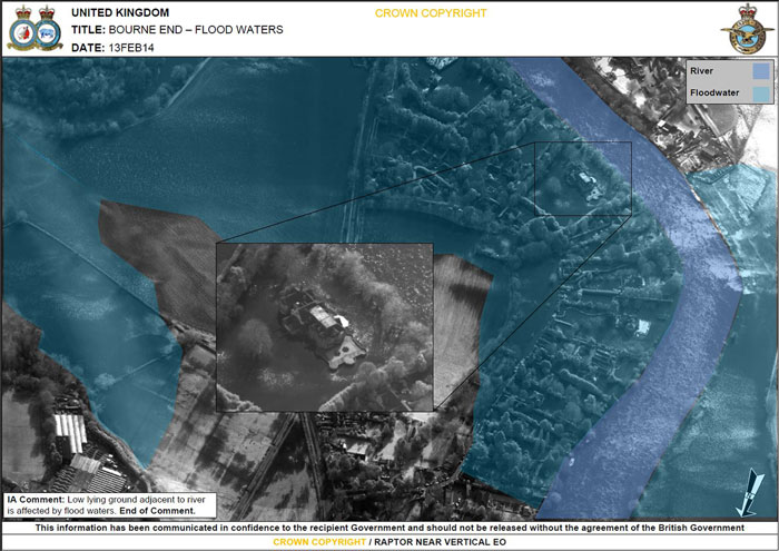
The
Royal Air Force launched one of its Tornado strike fighters on Thursday
February 23, 2014 to capture a highly detailed aerial picture of the
areas affected by the floods in southern England, after a request by
Gold commanders in the Thames Valley. The aircraft, operated by the
RAF’s 31 Squadron, is equipped with the highly versatile RAPTOR –
Reconnaissance Air Pod for Tornado – which enables it to gather
high-resolution imagery. Photo: Crown Copyright

The air crew of the Sentinel monitoring surveillance images collected in flight. Photo: UK MOD, Crown Copyright

Sentinel R1 aircraft operated by No 5 Squadron. Photo: UK MOD, Crown Copyright

No comments:
Post a Comment