Underwater Streetview
Posted by Sam Churchill on September 26th, 2012The panoramic images were collected by Google’s partner, The Catlin Seaview Survey used a specially designed underwater camera, the SVII, to capture the photos. It travels at 3-4km per hour utilising 3 separate Canon 5D cameras taking in excess of 3,600 images per run.
Xeni Jardin spoke with Richard Vevers, Project Director at Catlin, and asked why the organization chose to partner with Google on this project.
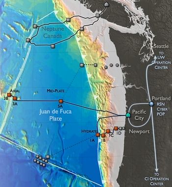
The Ocean Observatory Network landed in Oregon last summer. This year the Ocean Observatories Initiative Regional Scale Nodes team completed a significant construction milestone in August with installation of the primary nodes for the cabled component of the Ocean Observatory infrastructure that extends some 300 miles off the Oregon Coast.
A team of scientists studying last year’s eruption of Axial Seamount now says that the undersea volcano some 250 miles off the Oregon coast gave off clear signals hours before the eruption. Scientists, using seismic analysis, were able to see how the magma ascends within the volcano about two hours before the eruption.
Oceanographers John Delaney, Deborah Kelley and others at the University of Washington are guiding the development of the regional cabled ocean observatory, off the coast of Oregon that encompasses the Axial Seamount.
BTW, isn’t it time somebody invented a box that lets you plug in at least 5 HD cameras? Three of those cameras might be dedicated to an ultrawide panoramic video (720 x 4000 pixels) and two could be dedicated to static views. Alternatively, all five could create a 360 degree panoramic video. After shooting, you could “virtually zoom” to any part of the video image (without multiple camera operators). Handy for high school sports.
Maybe that’s a cloud service using Elemental Technologies and AppFog. Surround imaging companies in Portland include iMove, Immersive Media and GigaPan.


No comments:
Post a Comment