Geosync Spies
Posted by Sam Churchill on January 15th, 2009 A launch attempt of the Delta 4-Heavy rocket carrying an NRO reconnaissance satellite (NROL-26), with a rumored 300 foot mesh antenna will not occur this evening, reports SpaceFlight Now. The United Launch Alliance launch has been rescheduled for Jan. 17, 7:33 p.m. EST. Weather was the main reason the launch was rescheduled for Saturday.
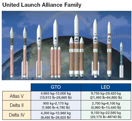
The Heavy is the largest Air Force rocket in the family of Evolved Expendable Launch Vehicles. It is capable of throwing more than 14 tons into geosynchronous space or 50,000 lbs to LEO. The Heavy is making its third flight following a demonstration test launch conducted in December 2004 and the first operational mission in November 2007 that orbited a missile-warning satellite.
The combined cost of the NROL-26 spacecraft and booster is upwards of $2 billion, says Aviation Week’s Craig Covault.
Huge antennas are now being used by commercial satellites such as ICO G1 and Inmarsat 4.
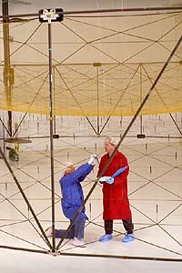 ICO G1, the largest commercial satellite launched to date, successfully deployed its Harris 12-meter reflector in April, 2008. The Harris antenna (pdf) on the ICO satellite utilizes a gold-plated mesh reflective surface with a unique design that allows a very large antenna reflector to stow safely and easily on the Loral 1300 satellite platform. The reflector size enables the increased performance typically required for mobile interactive media services. ICO G1 will deliver mobile interactive media services, like mobile video, interactive navigation and emergency communications services to consumers.
Harris has also built a reflector for TerreStar Networks’s geostationary TerreStar-1 mobile communications satellite; and two reflectors for XM Satellite Radio’s XM-5 radio broadcast satellite.
Competitor Astro Aerospace, a subsidiary of Northrop Gruman, has also designed and deployed large 12.25 meters (40 feet) AstroMesh reflectors for Thuraya, Inmarsat 4 and Japan’s Mobile Broadcasting satellite program.
But these 12 meter (40 foot) mesh reflectors on commercial satellites would be puny compared to a 100 meter (300 foot) monster rumored on board the NROL-26 SIGINT bird.
The dean of aerospace journalists, Craig Covault now writes for SpaceFlightNow. Covault implies that the Delta IV Heavy may be packing heat inside its 5-m (16.6-ft) diameter fairing.
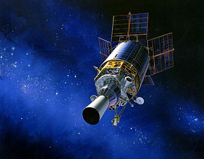
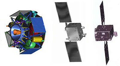
In a top secret operation, the U.S. Defense Dept. is conducting the first deep space inspection of a crippled U.S. military spacecraft. To do this, it is using sensors on two covert inspection satellites that have been prowling geosynchronous orbit for nearly three years.The failed satellite being examined is the $400 million U.S. Air Force/Northrop Grumman Defense Support Program DSP 23 missile warning satellite. It died in 2008 after being launched successfully from Cape Canaveral in November 2007 on the first operational Delta 4-Heavy booster.
The Orbital Sciences and Lockheed Martin “Mitex” inspection spacecraft involved are part of a classified Defense Advanced Research Projects Agency (DARPA) technology development program. When initially launched on a Delta 2 from Cape Canaveral in 2006, the project involved maneuvering around and inspecting each other at geosynchronous altitude.
 |  |
The US currently accounts for roughly 95 percent of total global military space expenditures with approximately 130 operational military-related satellites – over half of all military satellites in orbit, says spacesecurity.org (pdf).
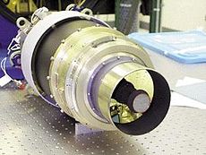
The LEAP program pioneered the development of small, miniaturized kill vehicles atop the Standard SM-3 missile for better range and accuracy. It beat out a proposed A-Sat system, Brilliant Pebbles, that used a thousand small, highly intelligent orbiting satellites with kinetic warheads.
The Autonomous Nanosatellite Guardian for Evaluating Local Space (ANGELS) program, such as the XSS-11 is intended to provide the continuous monitoring of assets in GEO. Draper Labs worked on the XSS-11 for autonomous satellite inspection and TacSat-2 (pdf).
SpaceDev manufactured the Trailblazer satellite selected by the Operationally Responsive Space Office. After being launched Trailblazer would have collected image data and communicated with a ground station but was on-board the ill-fated Falcon 1.
![]() The Russian Almaz program, launched by the Soviet Union under cover of the civilian Salyut program, included anti-satellite protection, says Nova’s Astrospies web site (left). The Russian Space Web has more info.
The Russian Almaz program, launched by the Soviet Union under cover of the civilian Salyut program, included anti-satellite protection, says Nova’s Astrospies web site (left). The Russian Space Web has more info.
The International Scientific Optical Network, primarily a Russian venture, has discovered 152 ‘unknown’ objects, likely including classified US satellites, that have no public orbital information in the US catalogue. It also has also tracked 192 previously unknown faint space debris objects in geosynchronous orbit.
Besides the U.S. and Russia, China and Japan launch spy satellites. Israel has a spy satellite program, as does NATO, the United Kingdom, and France. Whether or not the Russians will now test an ASAT weapon may be an open question. The Missile Wars (FrontLine) may be heating up.
Politics aside, the unfurling of a 100 meter antenna on board a geosynchronous spacecraft would have to be viewed as a major milestone for telecommunications world-wide. The $2B secret reconnaissance satellite is a high-risk, high-stakes gamble.
Besides the MENTOR (Advanced Orion) geosynchronous ELINT birds, other NRO programs and NROL designations might include:
- Magnum: USA-8/48/67
- Trumpet: USA-103/112/136
- Mercury: USA-105/108/FTO
- Mentor: USA-110/139/171
- Prowler: USA-184/200/TBD

Geosynchronous ELINT satellites are like aircraft carriers. They may need a fleet of spacecraft for support and self-defense.
We all get to watch.
You can follow the action on SeeSat-L’s archives, the NASA Spaceflight Forum or United Launch Alliance’s own Live Webcast.
Meanwhile, Canada’s Radarsat 2 satellite was successfully launched more than a year ago while high resolution sat photos can be ordered from GeoEye, DigitalGlobe and Spot and are used on Google Maps and Microsoft Live.
source: dailywireless.org




No comments:
Post a Comment